Web Dev Stuff

HTML5
Read the HTML5 for Web Designers book by Jeremy Keith.

CSS
Went through the whole W3C CSS tutorial to brush up on the skills. Took lots of notes that are in draft mode.

JAVASCRIPT
Will go through W3C JavaScript tutorial as well.

GRIDS ARE GOOD
Considering responsive/adaptive web design as a framework, but unsure how our geolocation-based visualizations on top of a map will work if we take an approach like this.
http://goldengridsystem.com/
http://cssgrid.net/
http://www.designinfluences.com/fluid960gs/16/
http://mediaqueri.es/

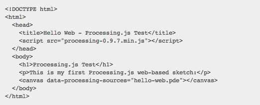
HTML5 CANVAS FOR ANIMATION
Testing pretty simple stuff here: http://paintyourcity.com/viz/

Based on tutorials like these:

https://developer.mozilla.org/en/Canvas_tutorial/Basic_usage
http://thinkvitamin.com/code/how-to-draw-with-html-5-canvas/
http://dev.opera.com/articles/view/html-5-canvas-the-basics/

Not really working at all. Grrr. Will update all my browsers.
Data Storage Options

GOOGLE FUSION TABLES
250 MB storage limit per user account, 1 million characters per cell
upload limits—1 MB per spreadsheet, 100 MB per .csv or kml

To get more space, you have to have and work through the Maps API Premier account
Purchase more storage space for Fusion Tables: Google Groups Thread

How to query from google fusion table: Google Dev Guide

CLOUD MINE
Get data storage, user accounts and server-side code with Cloud Mine

FILES ON OUR OWN SERVER
Instructions for parsing data from a .gpx file into processing

Advice from Open Plans

As I mentioned in the previous post, the MVP itself has its complexities. Here is the run-down of the layers involved for the mapping software.

1. Map tiles (provided by Open Layers, Poly Layers, Google)
2. Routing services (Open Trip Planner, NavItGoogle)
3. NYC bike network (found on the nyc.gov GIS file)
4. Software for to convert turn-by-turn directions to audio and re-route
5. GPS tracking

Other notes from meeting at Open Plans:
Connect with the bike nerd community: Get biking software developers together to lead a discussion and work session for how the thing can be developed. Check out Bike NYC Tech meet-up.

Note: We need to draw the line between what we will program and what we will get help with.

Research: apps and open-source software for turn-by-turn directions and routing, geo-fencing, place-based audio tools, Rodify, Ways, Filter Bubble (book), Android extension kit

Connect with Transportation Alternatives, Ride the City, and NYC Bike Tech meetup

The Google Directions API

The Google Directions API is a service that calculates directions between locations using an HTTP request.

Note the following:

This service is generally designed for calculating directions for static (known in advance) addresses for placement of application content on a map; this service is not designed to respond in real time to user input, for example. For dynamic directions calculations (for example, within a user interface element), consult the documentation for the JavaScript API V3 Directions Service.

Still, by using the Google Directions API, you can get directions through putting URLs into the address bar on JSON or XML format. Here are som tests:

Home to Purpose:
http://maps.googleapis.com/maps/api/directions/json?origin=519+5th+st,+brooklyn,NY&destination=224+centre+st,NY&mode=bicycling&sensor=false

Home to Purpose – via Brooklyn bridge using waypoints:
http://maps.googleapis.com/maps/api/directions/json?origin=519+5th+st,+brooklyn,NY&destination=224+centre+st,NY&waypoints=brooklyn+bridge,NY&mode=bicycling&sensor=false
…though this breaks the route into two legs, and the directions says “destination will be on your left” also when I’m on Brooklyn Bridge…

Home to Purpose – alternative routes:
http://maps.googleapis.com/maps/api/directions/json?origin=519+5th+st,+brooklyn,NY&destination=224+centre+st,NY&alternatives=true&mode=bicycling&sensor=false

XML instead of json (json is recommended though):
http://maps.googleapis.com/maps/api/directions/xml?origin=519+5th+st,+brooklyn,NY&destination=224+centre+st,NY&mode=bicycling&sensor=false

This was the service I used when getting directions for the Low-fi prototyping, part II, which I then turned into a text file ready to be read by the guy from Speak It!

Some issues:

  • The directions do not seem to have information about bike path/lane in Google Maps. The Ride the City app does have this information.
  • For knowing the user’s current location, we might need to use the Official Google JavaScript API.